Soubor:Tettstedet Oslo 2005.png

Velikost tohoto náhledu: 800 × 458 pixelů. Jiná rozlišení: 320 × 183 pixelů | 640 × 366 pixelů | 985 × 564 pixelů.
Původní soubor (985 × 564 pixelů, velikost souboru: 154 KB, MIME typ: image/png)
Popis
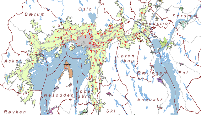
| Popis | Map of tettstedet Oslo made by Statistisk Sentralbyrå based on data of 01.01.2005. |
| Datum | |
| Zdroj | http://www.ssb.no/emner/01/01/20/tettstedkart/fylke0203.pdf |
| Autor | Statistisk sentralbyrå (Statistics Norway). |
| Svolení (Užití tohoto souboru) |
Statistics Norway freely permits saving, printing, copying and spreading of the material on this web site (text, tables and figures). Statistics Norway must be credited when using the material. ( |
Norsk bokmål: Kilde: Statistisk sentralbyrå. Kartet er beskåret av meg.
Bruk av SSBs materiale:
Statistisk sentralbyrå gir tillatelse til at materiale på dette nettstedet (tekst, statistiske tabeller og figurer) fritt kan lagres elektronisk, skrives ut, mangfoldiggjøres og videreformidles. Tillatelsen forutsetter henvisning til kilden stoffet er hentet fra (kilde: Statistisk sentralbyrå). Kildehenvisning skal angis i direkte tilknytning til hver tabell og figur som benyttes. (Tatt fra [1])
English: Source: Statistics Norway. The map is cropped by me, Jorunn.
Using Statistics Norways material:
Statistics Norway freely permits saving, printing, copying and spreading of the material on this web site (text, tables and figures). Statistics Norway must be credited when using the material. (Translation of [2])Licence

|
Držitel autorských práv k tomuto souboru dovoluje jeho užití komukoli pro jakýkoli účel, za podmínky, že je držitel práv správně uveden. Další šíření, tvorba odvozených děl, komerční využití i všechna další užití jsou dovolena. |
|
|
Historie souboru
Kliknutím na datum a čas se zobrazí tehdejší verze souboru.
| Datum a čas | Náhled | Rozměry | Uživatel | Komentář | |
|---|---|---|---|---|---|
| současná | 10. 7. 2006, 00:48 | | 985 × 564 (154 KB) | wikimediacommons>Jorunn | {{Information |Description= Map of tettstedet Oslo made by Statistisk Sentralbyrå based on data of 01.01.2005. |Source= http://www.ssb.no/emner/01/01/20/tettstedkart/fylke0203.pdf |Date=2005 |Author=Statistisk sentralbyrå (Statistics Norway). |Permissi |
Využití souboru
Tento soubor používá následující stránka: